©2021 Reporters Post24. All Rights Reserved.
Satellite Vu is attracting a lot of interest with its plans to fly a network of spacecraft to map heat signatures across the planet.
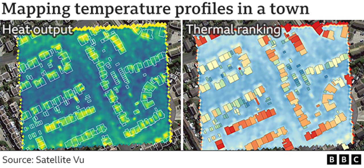
Such observations have long been made, but not at the resolution (3-4m) and frequency (several times a day) that the London firm is promising.
This will allow Satellite Vu to map the temperature profiles of individual buildings, offices and factories.
If you want to know where the most inefficient housing stock is in a city, where energy is being wasted, where you could best target insulation expenditure – the new thermal data-sets will tell you.
The information could make a significant contribution in helping the country meet its net-zero commitments.
Satellite Vu will sign a contract on Wednesday at the Farnborough Air Show for a second spacecraft.
It’s already got one about to go into build with Guildford manufacturer Surrey Satellite Technology Limited (SSTL). A second will get Satellite Vu one-quarter of the way to an eventual eight-platform constellation in the sky by the end of 2025.
The spacecraft will sense the ground at mid-wave infrared wavelengths (3.7-4.95 microns). That’s light beyond what most Earth observation satellites and our eyes can discern, but it’s where the heat energy retained in structures will show up.
“With infrared, what you see in daytime, you can see at night. And whereas most other Earth observation data-sets are looking at the outside of buildings, we can even get an inference of what’s going on inside – whether there’s activity in that building, whether a house is occupied, whether there’s productive machinery in a factory,” said Anthony Baker, CEO and co-founder of Satellite Vu.
The company has so far raised £20m in funding. It has been flying a version of its satellite sensor on an aeroplane, to test data processing algorithms and to demonstrate to potential customers what can be achieved.

 IMAGE SOURCE,SATELLITE VU
A parked plane will shadow the ground, leaving a cool outline of itself on the airfield apron after departure
The applications are broad, and Satellite Vu is working with UK universities and running hackathons to devise new ways to exploit the information.
As well as describing the heat profile of buildings, the satellites will quickly identify the structures and open spaces that exacerbate the urban heat island effect. These include the large car parks at retail centres that pump up the temperatures in towns and cities. Planners would get an idea of where best to plant trees to cool the environment.
The data will also provide intelligence to the financial and insurance sectors – and even the military – by showing how temperatures in a scene have changed. It’s possible, for example, to see that planes recently left an airfield from the cool “ghost images” they leave behind having earlier shadowed the ground from the Sun.
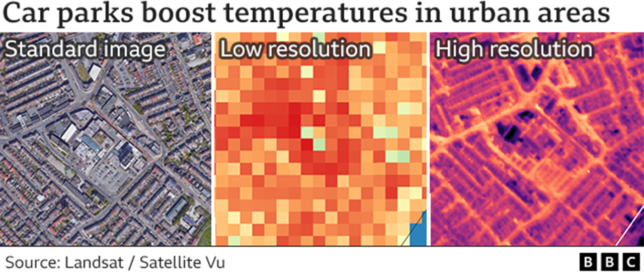
At left is the view taken with a standard optical satellite. In the middle is the publicly available resolution up to now. At right is the simulated resolution that Satellite Vu’s network should achieve. The heat (yellow colour) coming up from the asphalt in the big car park and from local roads is immediately obvious.
“This kind of data-set has not been available commercially before, not at this resolution,” said Andrew Cawthorne, the director of Earth observation at SSTL.
“Who’d have thought you could monitor the ocean for plastic pollution, but in the infrared you can. These ‘islands of plastic’ you hear about will show up as hotspots.”
Satellite Vu chief technology officer and co-founder, Tobias Reinicke, reckons one of the company’s key applications will be in checking the efficiency of the giant solar farms now springing up around the UK.
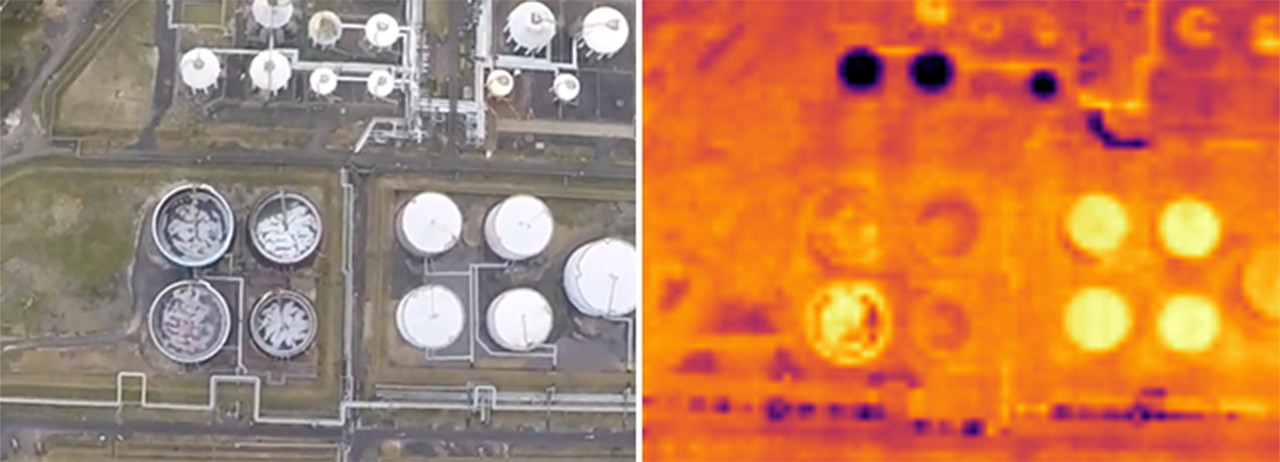 IMAGE SOURCE,SATELLITE VU
Can you tell what’s in these storage tanks? Their heat signature provides clues
“The hotter the solar panels are, the more problems they’ve got. Drones will obviously be used to see failures on centimetre-scales, but that’s quite expensive. We can routinely monitor the farms to detect failures in long strings of panels,” he told BBC News.
The UK Space Agency (UKSA) recently gave a grant to Satellite Vu to help with the development of the infrared sensor.
“Earth observation is a really interesting commercialising sector. There are some great companies out there, and whether they are headquartered in the UK or not, they all want to work in the UK,” said UKSA CEO Paul Bate.
Satellite Vu will launch its first satellite early next year.